A reference player in Geographic Information Systems (GIS) services and solutions in Morocco. For over 10 years, we support our public and private clients in the digital transformation of their spatial assets.
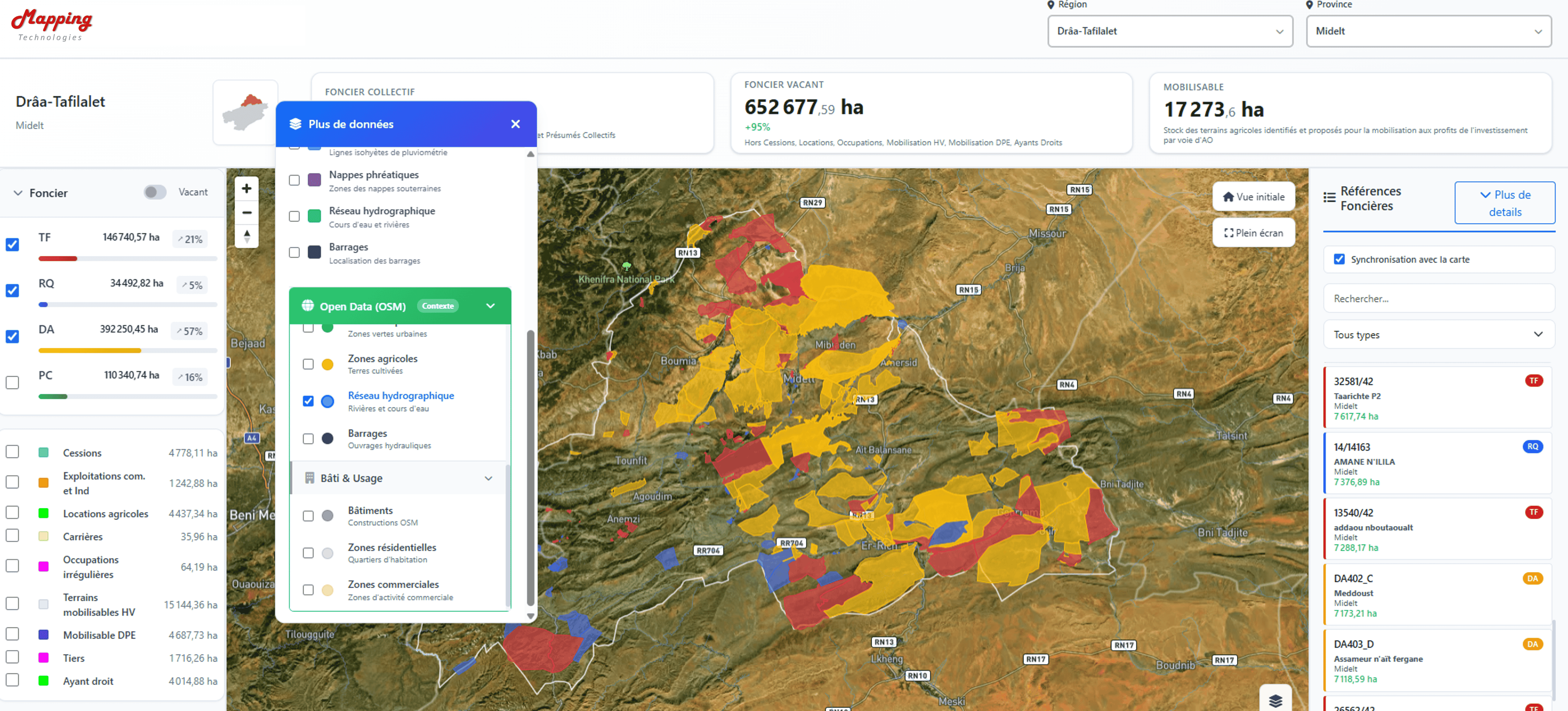
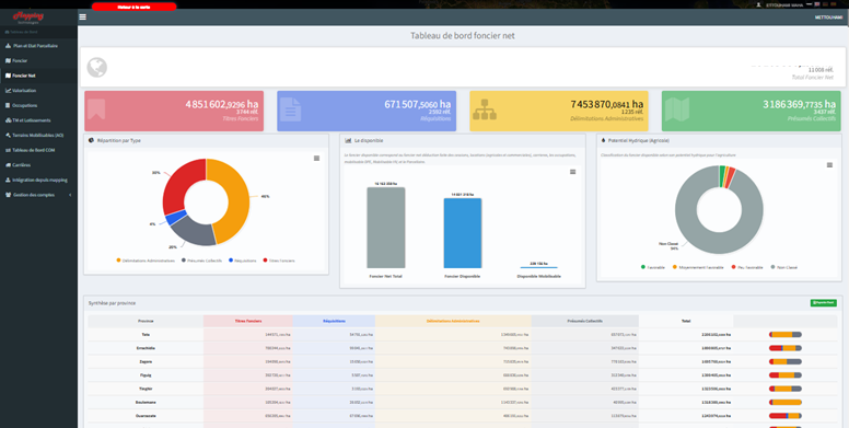
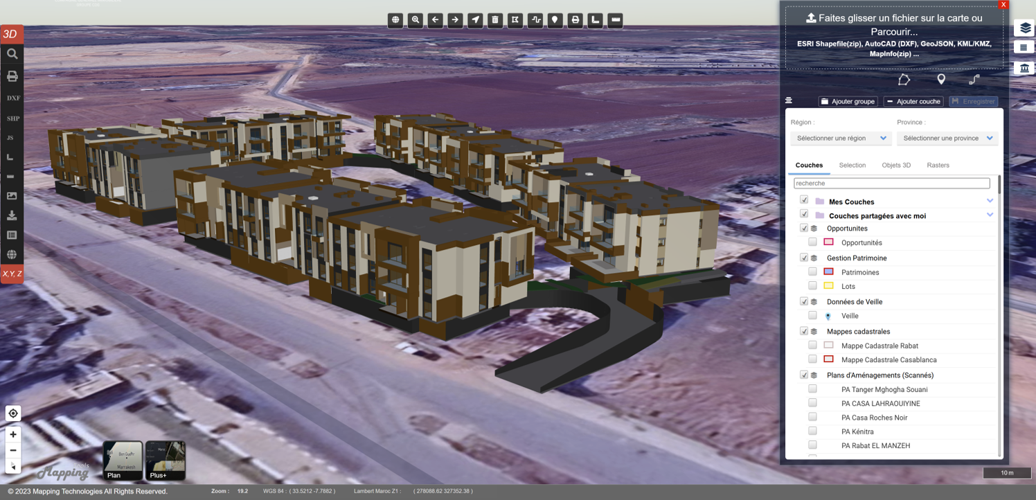
Comprehensive solutions for your geospatial and real estate projects
GIS audits, SI urbanization, geographic data governance, training and skills transfer to technical teams, migration of existing systems to modern GIS architectures.
Business solutions in land, real estate, environment, sustainable development domains. Web mapping interfaces, mobile applications, dashboards.
Interoperability via OGC standards (WMS, WFS, GML...), PostgreSQL/PostGIS spatial databases, cloud or on-premise deployment, application infogérance.
Dynamic mapping, dataviz and dashboards, spatial analysis, territorial modeling, decision indicators, integration with BI or open data tools.
Harness AI power to enrich your GIS systems and facilitate decision-making.
Support your teams with adapted and valuable skill development programs.
Innovative platforms developed by our team
Mapping.Tools is an innovative web GIS solution designed to transform your geographic data into powerful and accessible decision support tools.
Designed to adapt to all contexts – whether public or private, local or global – it combines ergonomics, versatility and interoperability to meet your business challenges.
MapBIM is an innovative solution for collaboration around BIM projects, combining digital models and geographic information systems.
Specially designed for built heritage management and construction site monitoring, it integrates IFC/GLTF models with cartographic layers for a complete vision of your projects.
Over 15 major institutional projects delivered
Regional information systems for environment and sustainable development. Web platform for environmental monitoring and sustainable development indicators tracking at regional scale.
Geographic information system for monitoring the evolution of agricultural plastic waste sector in the Sous-Massa region.
GIS solution for land prospecting and land asset management.
National Geographic Information System for collective land management: a land heritage of over 15M Ha.
SIGDOM platform for collection and digitization of spatial reference data related to state land and real estate heritage.
Development of integrated solution for land asset management, operations monitoring and contract management.
SEBOU Water Fund Geoportal for management and monitoring of water resources with interactive mapping
National Environmental Information System for environmental monitoring and analysis at national scale.
GIS platform for consolidation and management of managed land assets for optimization and enhancement of real estate assets.
Institutions and organizations that trust us
We are proud to collaborate with government institutions, international organizations and leading companies in our areas of expertise.
Mapping Technologies is a reference player in Geographic Information Systems (GIS) services and solutions in Morocco. For over 10 years, we have been supporting our public and private clients in the digital transformation of their spatial assets.
We combine technological expertise, in-depth knowledge of the Moroccan territory and continuous innovation to offer high value-added geospatial solutions. Our proven methodological approach is based on customer satisfaction-centered innovation and high standards of commitment compliance.
Let's discuss your project
Our team of experts is at your disposal to study your needs and propose adapted solutions.
Sector 25, Building B, Riad AL OTOR HAY RIAD, Rabat, Morocco
+212 537 71 04 72
contact@mapping-technologies.com